
The BCCI press conference scheduled at 1.30pm in Mumbai is 'expected to be delayed owing to weather disruptions'.

Cyclone Ditwah exits Sri Lanka after causing widespread destruction and over 120 deaths, heading towards the Indian coast. Heavy rains and high winds are expected to continue.

North India is shivering under an intense cold wave as temperatures plummet across the region.
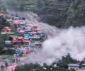
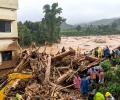
A cloudburst in the high altitude villages of Dharali in Uttarkashi district of Uttarakhand led to flash floods, causing damage to houses and sweeping away structures. Several people are feared buried under debris.

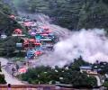
At least 23 people, including children, were killed as relentless rain triggered one of the worst landslides in a decade in Darjeeling hills and adjoining areas on Sunday, sweeping away homes, cutting off roads, isolating villages, and leaving hundreds of stranded tourists amid widespread devastation, officials said.

A landslide on the Kedarnath route in Uttarakhand killed two pilgrims and injured six, while heavy rain led to the temporary suspension of the Char Dham and Hemkund Sahib pilgrimages.
A new study identifies flash flood hotspots in India, highlighting the influence of land features, rainfall, and the growing impact of climate change.

Mumbai Indians were the first team to leave the field while Delhi players stayed back doing light training but were eventually forced to call it off.

Heatwave may abate over most parts of North India in next two days; temperatures likely to drop by 2-3C.

The officials identified the deceased as Ashwani Sharma (24), his brother Dwarka Nath (55), niece Virta Devi (26) and their guest Om Raj (38), a resident of Banshara in Rajgarh. The rescuers are searching for Sharma's sister-in-law, Bidya Devi (55).

After being pummelled by heavy downpours at the start of the week, Mumbai witnessed a brief respite on Tuesday morning, with the island city recording an average rainfall of 106 mm in 24 hours, civic officials said.
The Army unit deployed in Ashti successfully evacuated 40 people with the help of an NDRF team and other agencies.
The southwest monsoon arrived in Maharashtra on Sunday, making it the earliest onset of the annual rainfall season over the state in 35 years, according to the India Meteorological Department. The monsoon is expected to advance to Mumbai and some other parts over the next three days. The monsoon advanced into some more parts of the Arabian Sea, Karnataka, entire Goa, parts of Maharashtra, north Bay of Bengal, and parts of Mizoram, parts of Manipur and Nagaland on Sunday. The northern limit of monsoon passes through Devgad, Belagavi, Haveri, Mandya, Dharmapuri, Chennai, Aizawl and Kohima. Conditions are favorable for further advance into some more parts of central Arabian Sea, more parts of Maharashtra including Mumbai, Karnataka including Bengaluru, some parts of Andhra Pradesh, remaining parts of Tamil Nadu, more parts of west-central and North Bay of Bengal and some more parts of North Eastern states during next three days. The southwest monsoon hit Kerala on Saturday, marking its earliest arrival over the Indian mainland since 2009.

Mumbai recorded a minimum temperature of 16.5 degrees Celsius on Friday, the lowest for November in the last eight years, the India Meteorological Department (IMD) said. This temperature was recorded by the Santacruz observatory, which records weather parameters for Mumbai's suburbs. The Colaba observatory, which records weather parameters for the island city, registered a minimum temperature of 21.4 degrees Celsius during the same period. There is no cold wave alert for Maharashtra from November 30 to December 3, and temperature is set to rise.

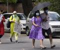
A thunderstorm accompanied by heavy rain battered Delhi overnight, disrupting flight operations, uprooting trees and electricity poles, and causing waterlogging in several areas while bringing relief from stifling heat. The sudden change in weather led to a sharp drop in mercury with the city recording a minimum temperature of 19.8 degrees Celsius, 6.9 notches below the normal. The India Meteorological Department said the city's primary weather station at Safdarjung recorded winds gusting up to 82 kmph and 81.2 mm of rain in six hours -- between 11.30 pm and 5.30 am.

A massive landslide struck the old track to the Vaishno Devi shrine in Reasi district of Jammu and Kashmir on Monday, leaving one pilgrim dead and 10 others injured, officials said.

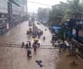
Heavy overnight rain in Gurugram caused widespread waterlogging and traffic gridlock, bringing the city to a standstill. Several residential areas and major roads were inundated, leading to commuter chaos.
'The lakes up there were already at the brink due to accumulated rainwater, and then snowmelt occurred.' 'When one lake breached, it triggered a cascading effect -- other lakes breached subsequently.'
The frequency of short-duration, heavy rainfall events over central India and long-duration heavy rainfall events over the north-western coasts of the country has risen considerably in the last few decades.

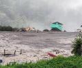
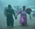
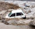
Heavy rains in Rajasthan lead to flooding, resulting in casualties and widespread disruption. Rescue operations are underway, and schools are closed in several districts.
A red alert indicates heavy to extremely heavy rain of over 20 cm in 24 hours. An orange alert means very heavy rain of 11 cm to 20 cm, and a yellow alert means heavy rainfall between 6 cm and 11 cm.

A steady drizzle in the evening brought premature end to evening practice sessions of Kolkata Knight Riders and Royal Challengers Bengaluru on the eve of their IPL 2025 opening match on Saturday.
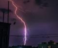
At least 25 people were killed in lightning strikes and hailstorms in several districts of Bihar, India, on Thursday. The India Meteorological Department has issued an 'orange alert' for a number of districts, forecasting heavy rainfall on Friday and Saturday. The state capital, Patna, recorded an average of 42.6 mm rainfall till 5.30 pm.

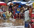
Heavy rains lashed several parts of Maharashtra, including Mumbai, on Monday, resulting in one death and the rescue of 48 people from inundated areas. The state received widespread rainfall, with Pune, Satara, Solapur, Raigad, and the Mumbai Metropolitan Region (MMR) experiencing significant precipitation. Mumbai recorded 135.4 mm of rainfall in the past 24 hours, leading to waterlogging and power outages in some areas. The India Meteorological Department has predicted more rain in Mumbai over the next 24 hours, accompanied by thunderstorms and strong winds.

The southwest monsoon has arrived in Mumbai 16 days before its usual date, making it the earliest arrival since 1950. This early onset follows the monsoon's arrival in Kerala, the southernmost state, on Saturday, marking the earliest arrival since 2009. The India Meteorological Department (IMD) predicts an above-normal rainfall for the 2025 monsoon season, with rainfall between 96 per cent and 104 per cent of the 50-year average of 87 cm considered 'normal'. The monsoon is crucial for India's economy, providing vital water for agriculture and replenishing reservoirs.

From the Sensex firms, Mahindra & Mahindra, HCL Tech, Tata Motors, Nestle, ITC, Hindustan Unilever, Larsen & Toubro, and Tech Mahindra were the biggest gainers. In contrast, Eternal, UltraTech Cement, Power Grid, Tata Steel and Kotak Mahindra Bank were among the laggards. Eternal dropped 4.51 per cent.
The India Meteorological Department (IMD) forecasts above-normal rainfall for India in September, following a monsoon season marked by heavy downpours and related disasters in various regions. The forecast indicates normal to above-normal rainfall for most areas, with some exceptions in the northeast, east, extreme south peninsular India, and parts of northwest India.
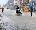
Mumbaikars woke up to very heavy rainfall on Monday, while the India meteorological department (IMD) issued a 'red' alert, forecasting extremely heavy rains at isolated places in the city and adjoining areas, prompting the civic body to declare a holiday for schools and colleges, officials said.
Temperatures are likely to remain in a similar range until Thursday, with a gradual fall expected from June 13.

Prime Minister Narendra Modi's visit to Pune in Maharashtra on Thursday was cancelled following heavy rains in the city, sources said.
The early onset of the southwest monsoon brought continuous rainfall across southern and eastern India, contributing to this record.

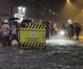
As many as 12 flights were diverted at the Delhi airport between 3 pm and 4 pm due to adverse weather conditions, an official said.

Strong demand for cultural and spiritual hubs is expected for destinations like Varanasi, Kolkata during Durga Puja, and Pushkar for the camel fair, besides leisure destinations like Goa, Udaipur, Jaipur and Coorg.

The forecast has an error margin of four days, which is considered normal

From a few rain gauges in 1875 to rivalling the world's best weather agencies, the India Meteorological Department (IMD) has weathered its way to becoming a global leader in forecasting.

IMD data shows in the 24 hours between September 1 and 2, Haryana received 806 per cent more rainfall than normal, Punjab 759 per cent, Himachal Pradesh 510 per cent, Delhi 740 per cent, Chandigarh a staggering 1,638 per cent, and Rajasthan 193 per cent.

Data since 2005 show that the five years with the highest rainfall saw average market returns of 8.98 per cent, while the five driest years returned 25.7 per cent on average.

Sri Lanka meteorological department predicts better weather in coming days
The India meteorological department said heatwave conditions will persist for at least two more days.
Heavy rainfall across North India leads to fatalities, structural damage, travel disruptions, and school closures. Eastern states brace for more rain.